
.png?width=650&name=fire%20featured%20(1).png)
Chris Spohrer, District Superintendent with California State Parks.
On August 16, 2020, a massive thunderstorm that produced close to 11,000 bolts of lightning in a single night started hundreds of fires throughout California. Two days after the fires began, wind conditions shifted dramatically, accelerating and merging many of the fires into a massive cluster of fires known as the CZU Lightning Complex fires, which ultimately burned 86,509 acres around Northern California.
One of the hardest-hit state parks in California is also its oldest. Established in 1902, Big Basin Redwoods features some of the oldest redwoods on the planet. With trees estimated to be more than 1,800 years old, these would predate the Roman Empire. In just 24 hours after reaching the park, the CZU fires had burned more than 97% of the park’s 18,000 acres. The fires were finally contained in December 2020. However, it was later discovered that many redwoods continued to smolder well into 2021.
We recently sat down for an interview with Chris Spohrer, Santa Cruz District Superintendent of the California State Parks. He is helping spearhead recovery efforts at Big Basin Redwoods State Park and helped explain how recovery unfolds after a natural disaster of this magnitude.
Watch interview on YouTube>>>
Q: I'M CURIOUS TO HEAR KIND OF YOUR POINT OF VIEW WHILE A WILDFIRE IS ACTIVE. IT SEEMS LIKE IT'S GOT TO BE A HELPLESS FEELING. ARE YOU BASICALLY WAITING?
A: To some degree, but you know, as the managers of large areas, we have a lot of responsibility to respond to events like that. And so leading up to what became the CZU fire event, we were monitoring the small lightning fires that had spread across the county, working very closely with CAL FIRE. On the evening of the 18th of August, the weather changed, and the fires grew rapidly and started moving into areas where we had campgrounds that were full. Big Basin state park in the middle of summer has over 225 campsites and cabins, and they were all full. So we moved very quickly into a full evacuation mode. We started evacuating all people in the park, including the residents that live in the park who worked for us. And then, once that was done, that was about a three-hour period, there was some waiting as the fire unfolded into sort of a firestorm that evening. And we were moved to the incident command post offsite. And then the next morning we were able to send an advanced fire train team from Parks into the park to assess the damage. And at that point, it was a pretty helpless feeling, getting the reports back of the devastation. Almost total loss of all the structures, incredibly intense fire in the basin, through the old-growth stands. That was tough. But pretty much immediately after that, you go into recovery mode.
Q: WHO IS INVOLVED IN THAT INITIAL RECOVERY PHASE?
A: Immediately we started working with the fire suppression agency, CAL FIRE. There's a lot of repair work that gets done after the initial suppression activity. So for parks, that means looking at areas where fireline went in, or where suppression activity caused impacts to the park. So we work hand in hand with CAL FIRE to repair that as best you can following a fire. And then following that, we started working on inventorying the losses.
We have responsibility for not just the natural resources but also the cultural resources. And because that is a historic park, a lot of historic resources had to be inventoried, cataloged, filmed, documented, etc. Then we start working with FEMA right away to start calculating the recovery costs. And then that moves right into working with partners like Cal OSHA and Cal Recycle for the actual clean-up. And in this case, because a highway runs directly through the park, we were also working very closely with Caltrans. And so trying to create safe access into the park, maintain that safe access, and then start addressing hazard trees and burn debris removal on all the building sites.
Q: I READ THAT SOME REDWOODS ARE AS TALL AS THE STATUE OF LIBERTY. SO I WOULD IMAGINE THAT TREES THAT FALL POSE SOME SORT OF RISK TO VISITORS IF THEY'RE SIGNIFICANTLY DAMAGED. SO HOW EXACTLY DO YOU ASSESS THE DAMAGE OF A TREE THAT SIZE?
A: It's somewhat of an overwhelming task in over 18,000 acres where we have 60 miles of roads and 70 miles of trail. We actually go through it very methodically, using criteria to establish what is a hazard tree. And that has to do with what the tree could hit, how likely it is to fall in the near future, etc. And we worked with a lot of professional foresters. We have our own professional staff that was involved with that and reviewing the analysis. We marked literally thousands of trees that had the potential to hurt people. And then went through and started removing those.
And I should say, for the most part, these are not redwoods. Redwoods have incredible resiliency to fire, even under intense heat as they saw in this fire. It was mostly Douglas firs, which don't have the same resilience. And a lot of understory trees like the tan oaks and live oaks. So those are most of the trees that came out. There were some redwoods that either shattered in the fire or were so damaged that they had to come down. But that was months and months and months with hundreds of people in there marking and then cutting and removing those trees. That was a big part of the recovery following the fire.
Q: SO IT SOUNDS LIKE REDWOODS ARE UNIQUE IN HOW THEY RECOVER FROM WILDFIRES?
A: Yes. These remarkable trees burned so hot that the entire tops blow out, the limbs burn off, and yet they can regenerate an entire crown from the trunk. That is unique. And almost all of them are sprouting from the burls at their base. And most people have seen that. But it's quite a different thing to see a large swath of the forest where the canopy has been completely charred, coming back to life. So yeah, you won't see that in most other species. If you look at the understory trees like the tan oaks and live oaks, the entire above-ground portion of the trees were killed. They are only root sprouting. So some haven't been killed entirely, but they are not re-sprouting from their trunks or branches the way the redwoods are.
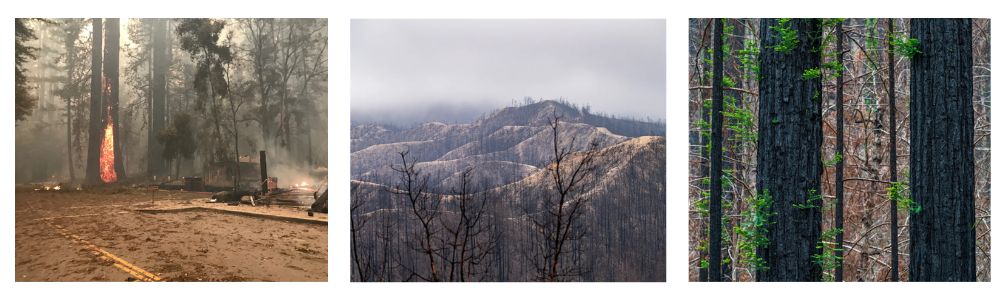 Photos showing the devastation of the CZU fires in Big Basin State Park. On the right: signs of recovery. See more>>>
Q: WHAT DOES FOREST RECOVERY LOOK LIKE IN A PARK THE SIZE OF BIG BASIN?
A: After an event like this, which is unprecedented, we thought the right thing to do, even though we have a general plan, which is the guiding document for the park, is to go back to the public and talk about the best way to reestablish this park. It was created over 100 years, pieced together, and built into a park, and we were suddenly faced with reestablishing basically the entirety of the park, so we wanted to have that shared public vision. So we spent the last year reimagining Big Basin with a lot of public input, and a lot of stakeholder input. And at the same time, we knew right away that we were going to have to look at the forest and its recovery differently than previous management of the forest. So we started doing fieldwork that would inform a forest management strategy.
A big theme that came out of this reimagining is that forest health is paramount to preserving this forest and making sure that it's healthy in the face of a changing climate, and for future generations to enjoy. And so part of that is looking at how are we going to steward the forest going forward. And I think one of the things that has come out of this is knowing that we're going to have less moisture out. It's going to be hotter and drier. Increased wildfire is a distinct possibility. So increasing our ability to manage the forest with prescribed fire is a big takeaway. And to do that, you have to have a very thoughtful layout of infrastructure so that you can use prescribed fire to manage the forest. So a big concept coming out of this reimagining is that the infrastructure the buildings, and the built environment, should be moved out of the old-growth. It should not be rebuilt where it was. And that means that the ability to manage the forest and reduce fuels will be easier. That will also mean restoring the ecological health of the forest, making sure that hydrologic connections are reestablished, and possibly recontouring areas that had been paved before. Really just ensuring that the health of the forest comes first, when we're thinking about redevelopment, are the big takeaways.
Q: IN RECENT YEARS WE'VE SEEN MORE AND MORE EVIDENCE THAT WILDFIRES WILL CONTINUE TO INCREASE IN FREQUENCY AND INTENSITY FOR A VARIETY OF REASONS, INCLUDING CLIMATE CHANGE, BUT ALSO LAND-USE CHANGES, ETC. ARE THERE ANY STEPS BEING TAKEN AS FAR AS PREVENTION GOES? LIKE WEATHER MONITORING, TRACKING LIGHTNING STRIKES, ETC.?
A: We're certainly doing a lot more monitoring and field surveys of the fuels. Right now, that's been a big response. One of the things that happened quite early was some technology was installed in a couple of the high points within the park perimeter in order to these are cameras, high definition cameras all around. And those are ways that both CAL FIRE and state parks and the public really can look at the physical landscape and report smoke and that sort of thing.
We did install a weather station during the facility cleanup and recovery in an area that would give us more high-resolution data. Right in the heart of the basin. We haven't had that before. We had sort of low-tech stuff 50 years ago, but this is automated. And it gives us real-time data for rainfall. And that's another thing. The fire goes through and of course, people are concerned with wildfire, but the following rainstorms and those events that could lead to debris flows can be just as devastating. I was very concerned about losing roads and other infrastructure after the CZU fire was contained. And we did we have had some failures of road culverts because they burned and because we were having to beat debris flows, but we didn't get as much rain as we might, which I think helped. There were events where we got 10 inches of rain in 24-hour periods. So we were monitoring that weather data during those periods.
Q: THE MASSIVE UNCONTAINED WILDFIRES CURRENTLY RAGING IN NEW MEXICO LAUNCHED AN EARLY START TO WHAT LOOKS TO BE AN EXPLOSIVE FIRE SEASON. DO YOU THINK THESE FIRES SIGNAL AN INCREASED RISK FOR THE REST OF THE AMERICAN WEST IN 2022?
A: I think the New Mexico wildfires are a symptom of prolonged drought exacerbated by a changing climate and years of fire suppression that provide conditions ripe for large-scale wildfire. Unfortunately, we can likely expect similar fires across the west this year.
You can read more about the Reimagining Big Basin project at www.reimaginebigbasin.org/

MORE WEATHER NEWS:
LOSING SLEEP OVER CLIMATE CHANGE
When we think of climate change affecting people all over the world, oftentimes images of major floods, fires, or other natural disasters come to mind. But a new study from the University of Copenhagen revealed that climate change is already impacting us in smaller ways than we might think. They looked at data from around 50,000 wristband activity trackers taken between 2015 and 2017 and were able to conclude that as nighttime temperatures increased, people lost up to 15 minutes of sleep a night on average.
READY OR NOT, THE ATLANTIC HURRICANE SEASON IS HERE
The Atlantic hurricane season officially began earlier this month, and experts are predicting yet another busy season for 2022. Already, the first named storm of the season, Tropical Storm Alex, surged over Cuba, Bermuda, and parts of South Florida just days after the season's opening. Partially emerging from remnants of Hurricane Agatha, a Category 2 hurricane that left at least 11 dead and 20 missing in areas surrounding Oaxaca, Mexico, Tropical Storm Alex took three lives in Cuba before flooding parts of Bermuda and south Florida. Factors like warmer water, cleaner air, an especially long loop current, and La Nina are all being cited by experts as drivers for the busy season.
COMBATING WILDFIRES ONE GOAT AT A TIME
A pilot program in California that’s aiming to cut down on dead vegetation that turns into dangerous wildfire fuel is utilizing an unlikely source to get the job done: goats. An accelerated buildup of vegetation along with other factors like warmer, drier climates and certain invasive species are all factors that have contributed to the increased number of devastating wildfires in the state. In fire seasons past, humans and herbicides have been called upon to thin the plants and brush that later become wildfire fuel, but tests are being done to evaluate the effectiveness and eco-friendliness of bringing in goats to do the job.
Back to: Newsletter