
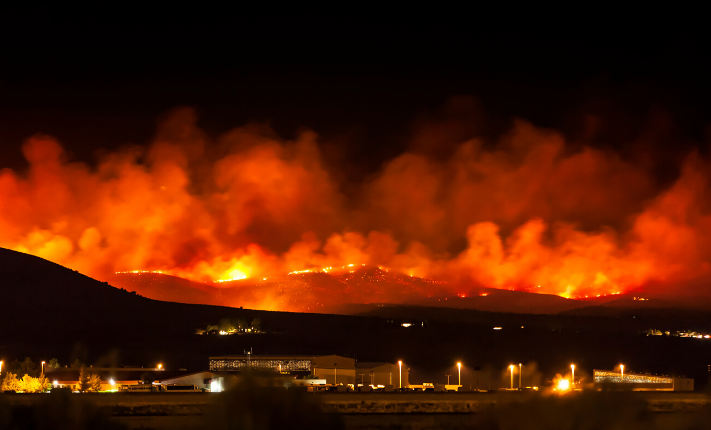
If firefighters could predict how a wildfire was going to spread, they would be better able to contain it. But despite great strides in the computer modeling used to forecast wildfires, they’re difficult to predict because of unexpected wind shifts or spontaneous acceleration. They remain a catastrophic force that takes lives and decimates communities.
Causes of wildfires
Roughly 85 percent of fires are sparked by human causes such as cigarettes, campfires, debris fires and arson, though climate also plays a role in increasing fire risk. Stanford researchers predict longer, more intense fires, with higher spring and summer temperatures quickly melting the spring snowpack, causing soil to dry out earlier and remain dry longer. After months of hot, dry conditions, forests can become susceptible to infestations by bark beetles and other wood-destroying insects that thrive in warmer temperatures. As these insects kill hundreds of millions of trees, the forestland is essentially transformed into kindling for wildfires.
The same trend of rising tempteratures and increased dryness applies to the entire U.S., and as the rising population pushes more people into at-risk areas, the risk of a human accidentally (or purposefully) starting a fire also increases.
Fire danger and risk assessment
Most of us have seen the “Smokey Bear” signs, which rank fire danger from low to extreme. Developed by the National Fire Danger Rating System (NFDRS) to inform the public of the relative fire hazard, this system ranks a region based on its fuel moisture (vegetation and its moisture content), topography, weather and seasonal changes. Property risk assessors use additional site-specific factors such as the slope, road access and wildland-urban interface, the proximity of a property to wildland.
Damage from wildfires
Over the past decade, fires have burned a yearly average of 6.9 million acres in the U.S., according to the National Interagency Coordination Center (NICC). That’s roughly the land area of Massachusetts. A total of 49,661 fires burning 4.6 million acres in 2019, less than in 2018 with 55,911 fires and 8.6 million acres.
California fires in particular have caused significant economic losses, destroying properties valued at roughly $80 billion in 2019, following an even more costly year in 2018 with $400 billion in damages. In fact, both the deadliest wildfire and the largest in California’s history occurred in 2018.
Deadliest California wildfire
On November 8, 2018, an aging powerline sparked a fire in Butte County, California, which spread rapidly down a steep slope to the town of Paradise, California. It led to 85 fatalities and destroyed 108,804 structures.
PG&E, the utility company responsible for the faulty powerline, has pled guilty to involuntary manslaughter and agreed to a settlement of $13.5 billion dollars for the victims.
Largest California wildfire
In July of 2018, California’s Ranch Fire and River Fire joined from opposite sides of California’s Clear Lake, leaving a huge burn scar impacting four counties in California. Now known as the Mendocino Complex Fire, it burned 410,203 acres, twice the size of New York City. Fortunately, it had a relatively low human impact, destroying just 246 structures and causing one fatality.
Current wildfire prediction techniques
In order to accurately forecast a fire, scientists create a fire model based on weather data, fuel moisture data, drought indices, and fire behavior data collected during real world fires. The NICC facilitates information sharing among different governmental agencies to ensure greater accuracy in fire prediction.
Prescribed burns also help scientists test fire models. In June of 2019, the U.S. Forest Service conducted a prescribed burn known as the Fire and Smoke Model Evaluation Experiment (FASMEE) in a remote location in Utah’s Fishlake National Forest. The experiment offered researchers across multiple governmental agencies the opportunity to conduct tests under conditions similar to ones that firefighters encounter.
Why forecasting wildfires is so difficult
Wildfire models are difficult to create, because they describe how a fire interacts with the existing conditions of a region. Such calculations require a “coupled” model, using equations to account for a fire’s atmospheric interactions. For instance, a fire produces heat, which can trigger faster winds, causing the fire to pick up speed.
Coupled fire models often require robust computing equipment and their calculations take a long time to process. Only a few fire existing models are able to produce fire predictions fast enough to keep up with the speed of an actual fire.
Since wildfires often occur in remote locations, scientists may lack the necessary wifi connection and access to a suitable power supply for their computing equipment to test their models and collect relevant fire weather data. Installing additional weather stations in remote areas could help solve this issue.
How weather stations help
In regions prone to wildfire, having access to wind direction and speed, as well as air pressure and precipitation can provide some indication of the severity and path of a fire as it approaches. For people living in a wildland-urban interface or a completely remote area, a home weather station can provide helpful site-specific information on fire risk factors. Organizations seeking to mitigate these same risk factors can similarly use networks of weather stations to inform researchers, first responders, and local communities.
Case Study: PG&E
The Camp fire was propelled by powerful winds in some places, even as weather stations just a few miles away in the Sacramento Valley registered little more than a light breeze. Following the Camp Fire legal settlement, it’s understandable that PG&E seeks to mitigate fire risks. PG&E's latest approach is a plan to install 1,300 weather stations by 2022 as part of its Community Wildfire Safety Program. So far, 600 stations have been installed across northern and central California.
“In many cases, there haven't been weather stations in close enough proximity to these fires to get a really good handle of what the conditions are actually like on the ground — we are essentially poking around in the dark,” says Daniel Swain, Climate Scientist at UCLA .
Experts analyze the weather station data out of the company’s Wildfire Safety Operations Center to make critical decisions about when to plan power shut-offs. The company coordinates its actions with the local public safety officials, adding to greater community awareness.
Understanding your fire risk
Anxiety-inducing wildfires can wreak havoc on communities. They also present particularly challenging patterns for meteorologists to model in real time. Until this technology develops further, property owners can reduce their fire risk with site-specific observations from a home weather station.

Back to: Articles, Extreme Weather